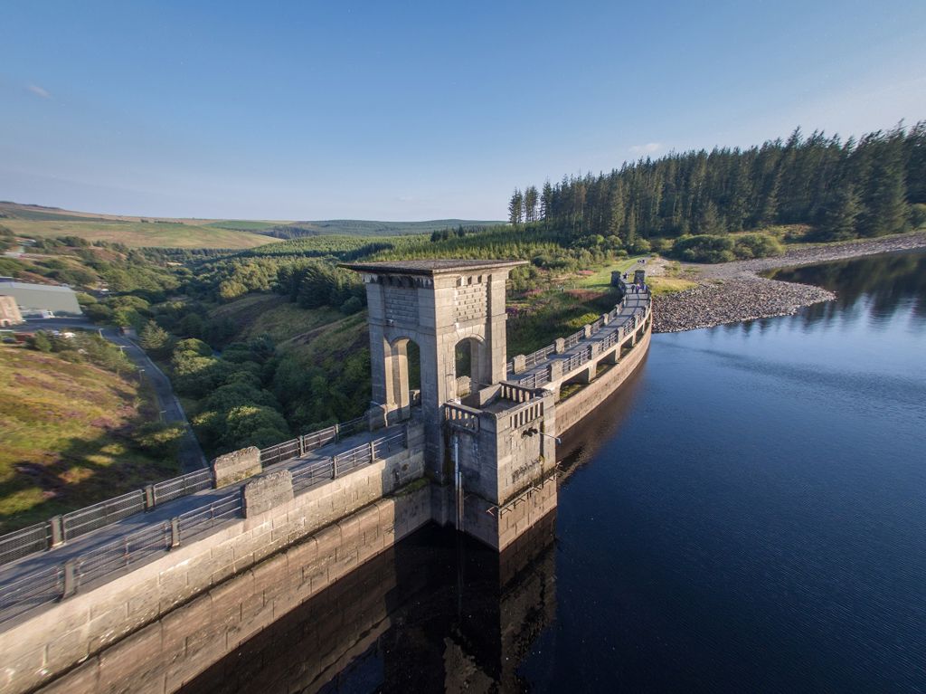
Clocaenog Forest - Bod Petryal, near Ruthin
Peaceful lakeside picnic site with short trails...

Alwen Reservoir and its huge dam were constructed in the early 20th century to provide water for the port of Birkenhead.
The car park is the starting point for several trails around the reservoir which can be used by walkers and cyclists.
There is a visitor centre at Llyn Brenig which is one mile from the entrance of the Alwen Reservoir car park.

These trails may be used by walkers and cyclists.
Most of the trails must be followed anti-clockwise by cyclists and clockwise by walkers – please follow the waymarkers.
Look out for the information panel at the start of the trails.
Find out about walking trail grades.
Find out about mountain bike trail grades.
This family friendly trail runs through forest, moorland and along the water’s edge on surfaced paths and forestry tracks – with ever-changing views across the reservoir and to the mountains in Eryri National Park.
Illustrated panels at the side of the path explore the wildlife, culture and folk tales of this historic upland landscape.
Follow this trail around the inner shores of both Llyn Brenig and the Alwen Reservoir.
Enjoy the open views and diverse scenery around both Llyn Brenig and the Alwen Reservoir.
Use this link route to join up the other trails or to take a shorter route between the two lakes.
The Lakes Circular and the Two Lakes Trail both go through Hafod Elwy Moor National Nature Reserve.
Hafod Elwy is a patchwork of high heath, moorland and bog, nestled between conifer forests and reservoirs.
This landscape is a haven for some of our rarest birds and Mynydd Hiraethog, which Hafod Elwy is part of, is one of the few remaining locations in Wales where you can still find both red and black grouse.
Many other native and visiting birds find shelter among Hafod Elwy’s heather and in spring skylarks return to nest here.
In summer the pinks and purples of heather carpet the moorland, while the white tufts of hare's tail cotton grass dot the areas.
You will also see the numerous bog mosses as 'lawns' of varying shades of green amongst the mounds of bilberry.
To find out more about what to see at the reserve look out for our information panel.
The Llyn Brenig visitor centre is managed by Dŵr Cymru/Welsh Water.
The entrance to Llyn Brenig car park is off the B4501, one mile from the entrance of the Alwen Reservoir car park.
For more information see the Llyn Brenig website.
We want you to return home safely after your visit here.
You are responsible for your own safety as well as the safety of any children and animals with you during your visit.
For advice and tips to help you plan your visit here go to Visiting our places safely.
See the top of this webpage for details of any planned closures or other changes to visitor facilities here.
For your safety, always follow instructions from staff and signs including those for trail diversions or closures.
We may divert or close trails whilst we undertake maintenance work or other operations and we may need to close other visitor facilities temporarily.
In extreme weather, we may close facilities at short notice due to the risk of injury to visitors and staff.
You may need permission from us to organise an event or to carry out some activities on our land.
Check if you are allowed to use our land.
We recommend you follow these directions or use the Google map below which has a pin on this place’s location.
Alwen Reservoir is 11 miles south west of Denbigh.
Take the B4501 from Denbigh towards Cerrigydrudion.
After 10 miles, go past the Llyn Brenig Dŵr Cymru/Welsh Water visitor centre car park and continue for 1mile.
The turning to Alwen Reservoir is on the right and the car park is at the end of a stoned track.
The Ordnance Survey (OS) grid reference for the car park is SH 956 529 (Explorer Map 264).
The postcode is LL21 9TT. Please note that this postcode covers a wide area and will not take you directly to the entrance.
View this place on the What3Words website.
The nearest mainline railway station is in Rhyl.
For details of public transport go to the Traveline Cymru website.
The car park at Alwen Reservoir is operated by Dŵr Cymru/Welsh Water.
The parking charge is £2.50.
You need to pay the parking charge with the correct cash as the machine does not give change.
There are no staff at this location.
Contact our customer team for general enquiries during office hours, Monday to Friday.