
Alwen Reservoir, near Denbigh
Walk or cycle around this huge upland reservoir
Pincyn Llys is in Clocaenog Forest, a huge area of woodland, open moorland and rivers.
This small roadside car park is the starting point for a short walk to the Pincyn Llys monument.
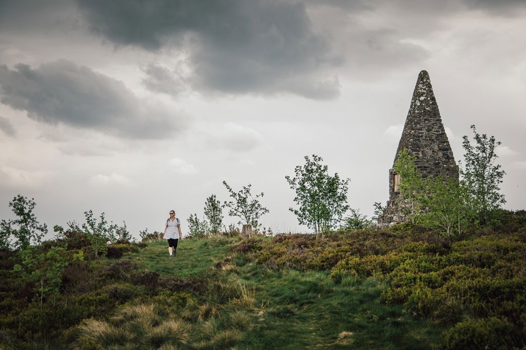
The monument is the highest point in Clocaenog Forest and there are views across the Vale of Clwyd.
Lord Bagot erected the monument in 1830 to commemorate the planting of a conifer forest.
The forest was cut down during the First World War to provide wooden props for the trenches and coal mines and it was then replanted by the Forestry Commission in the 1930s.
The starts from the information panel on the other side of the road to the parking area.
The walking trail is waymarked from start to finish.
Find out about walking trail grades.
The walk starts in shady woodland and makes its way to open moorland before the short but steep climb to the Pincyn Llys monument.
The full inscriptions on the monument are worth a read.
The monument stands at the highest point in Clocaenog Forest (1358ft/414m) and there is also an ancient earthwork and trig point with views across the Vale of Clwyd.
The walk returns to the car park along the same path.

The Hiraethog Trail goes through Pincyn Llys.
This trail links the villages of Pentrefoelas, Cerrigydrudion, Llanfihangel Glyn Myfr and Llanrhaeadr via public footpaths and quiet lanes across some of Denbighshire and Conwy’s most beautiful and remote countryside.
It may not be waymarked and we recommend that you take a map with you.
For more information go to the Denbighshire Countryside Service website.
Clocaenog is a huge conifer forest which is the size of 10,000 rugby pitches (100km2).
It lies at the southern end of Hiraethog Moor and was first planted in the 1930s by the Forestry Commission.
Although still a working forest, it is now a place for people to enjoy and home for a wide variety of wildlife.
Red squirrels live in Clocaenog Forest but you will be very lucky to see one as they move over large areas and are quite secretive.
Rare black grouse, known for their flamboyant courtship display, known as ‘lekking’, live on the forest edge.
In addition to Pincyn Llys, waymarked trails start from several other Natural Resources Wales car parks in Clocaenog Forest:
We want you to return home safely after your visit here.
You are responsible for your own safety as well as the safety of any children and animals with you during your visit.
For advice and tips to help you plan your visit here go to Visiting our places safely.
See the top of this webpage for details of any planned closures or other changes to visitor facilities here.
For your safety, always follow instructions from staff and signs including those for trail diversions or closures.
We may divert or close trails whilst we undertake maintenance work or other operations and we may need to close other visitor facilities temporarily.
In extreme weather, we may close facilities at short notice due to the risk of injury to visitors and staff.
You may need permission from us to organise an event or to carry out some activities on our land.
Check if you are allowed to use our land.
We recommend you follow these directions or use the Google map below which has a pin on this place’s location.
Pincyn Llys is 4½ miles south west of Ruthin.
Take the B5105 from Ruthin towards Llanfwrog.
After the church take the first right towards Telpyn.
Continue to Bontuchel and turn left after the small bridge onto a minor road towards Clocaenog.
After two miles, shortly after the road enters the forest, you will reach the start of the walking trail - look out for the Natural Resources Wales sign.
Parking is in the lay-by opposite the start of the walking trail.
The Ordnance Survey (OS) grid reference for the car park is SJ 064 556 (Explorer Map 264 or 265).
The postcode is LL15 2DH. Please note that this postcode covers a wide area and will not take you directly to the entrance.
View this place on the What3Words website.
The nearest mainline railway station is in Buckley.
For details of public transport go to the Traveline Cymru website.
Parking is in the lay-by opposite the start of the walking trail.
Parking is free of charge.
Overnight parking is not permitted.
There are no staff at this location.
Contact our customer team for general enquiries during office hours, Monday to Friday.


